A star chart is a two-dimensional projection of a three-dimensional sky. Learning to use one is a foundational skill — not because GoTo mounts are inadequate, but because knowing where you are looking, and why, changes how you observe. Observers who understand the coordinate system behind the chart notice patterns, track seasonal change, and plan sessions rather than simply pointing at whatever the computer suggests.
This article covers the two coordinate systems in common use, the magnitude scale, how to hold and orient a printed chart, and the specific adjustments needed for observers at Polish latitudes (roughly 49°–54°N).
The celestial sphere and coordinate systems
The equatorial system
Astronomers map the sky on an imaginary sphere centred on Earth. The celestial equator is the projection of Earth's equator onto this sphere. Positions are described by two coordinates: right ascension (RA) and declination (Dec).
Right ascension is measured eastward from the vernal equinox — the point where the Sun crosses the celestial equator in March. It is expressed in hours, minutes and seconds, running from 0h to 24h. One hour of RA corresponds to 15 degrees of angular separation. Declination runs from +90° (north celestial pole, near Polaris) to −90° (south celestial pole, not visible from Poland).
An object at RA 5h 35m, Dec −5° is M42, the Orion Nebula. That position in the sky is fixed relative to the stars — the equatorial coordinate system does not rotate with Earth. What changes is which part of the sky is overhead at any given time, depending on your location and the time of year.
The altitude-azimuth system
The alt-az system describes where an object is from the observer's local horizon at a specific moment. Altitude is the angle above the horizon (0° = horizon, 90° = zenith). Azimuth is the compass bearing, measured clockwise from due north: 0°=N, 90°=E, 180°=S, 270°=W.
Alt-az coordinates change continuously as Earth rotates. An object that rises in the east at azimuth 90° and altitude 0° at 21:00 will be at a completely different azimuth and altitude by 23:00. This is why atlas-style star charts use the equatorial system — they remain valid indefinitely — while planispheres and software displays use alt-az for real-time pointing.
Magnitude: the brightness scale
The magnitude scale runs counterintuitively: lower numbers indicate brighter objects. The Sun is magnitude −26.7. The full Moon is around −12.7. Sirius, the brightest star in the night sky, is −1.46. The human eye under dark skies typically reaches limiting magnitude 6.0–6.5. Most star charts plot down to magnitude 6.5.
A difference of 5 magnitudes represents a brightness factor of exactly 100. A difference of 1 magnitude is a factor of approximately 2.512 (the fifth root of 100). So a magnitude-3 star is about 2.5 times brighter than a magnitude-4 star and 100 times brighter than a magnitude-8 star.
On a printed chart, stars are represented by dots scaled to their magnitude — larger dot means brighter star. Charts for binocular or finder-scope use typically show stars down to magnitude 8 or 9. Detailed charts for deep-sky work with a telescope may reach magnitude 12 or beyond.
Planispheres for Polish latitudes
A planisphere is a rotating chart that shows which stars are above the horizon at a chosen date and time. The circular star map rotates behind a fixed oval window representing the local horizon. Planispheres are latitude-specific: a chart designed for 52°N (Warsaw) will show the correct sky from central Poland but will be inaccurate for observers at 49°N (southern Małopolska) or 54°N (Tricity, Pomerania).
When purchasing or printing a planisphere, check the latitude printed on the packaging. Planispheres calibrated for 50°N are adequate for most of Poland — the error at the horizon amounts to a few degrees, which is visible but not disorienting.
To use a planisphere: set the date against the time scale on the outer ring, hold the chart above your head with the horizon label facing the direction you are looking, and match the orientation to the real sky. The constellations on the chart should align with what you see overhead.
Orienting a printed atlas chart
Printed star atlases — such as Sky & Telescope's Pocket Sky Atlas or Uranometria 2000.0 — show the sky as if you are looking outward from Earth's surface. This means east and west on the chart are reversed compared to a geographic map. When you hold the chart above your head and face north, east appears on your left, west on your right — matching the sky as viewed from the ground.
For southern sky sections, rotate the chart so the south horizon label is toward you. East will then be on your right, west on your left, again matching the sky.
One way to build orientation quickly: find a known bright star — Vega, Arcturus, Capella — on the chart and match it to its position in the sky before navigating to nearby fainter objects. This anchor-point method is faster than trying to match the entire chart at once.
The seasonal sky from Poland
The constellations visible at midnight change through the year as Earth orbits the Sun. From central Poland, the key seasonal highlights are:
- Winter (Dec–Feb): Orion, Taurus, Gemini, Auriga are high in the south. M42 (Orion Nebula), M45 (Pleiades) and the double cluster h and Chi Persei are accessible even with modest aperture.
- Spring (Mar–May): Leo, Virgo and Coma Berenices. The Virgo galaxy cluster (including M87) is at a reasonable altitude, though dark skies help significantly.
- Summer (Jun–Aug): The Summer Triangle — Vega, Deneb, Altair — is nearly overhead. Cygnus and Aquila are rich in star clusters. The Milky Way core, in Sagittarius and Scorpius, is low on the southern horizon from Poland (Sagittarius peaks at only 15–20° altitude from Warsaw), making dark skies and a low, flat horizon essential for the brightest nebulae in that region.
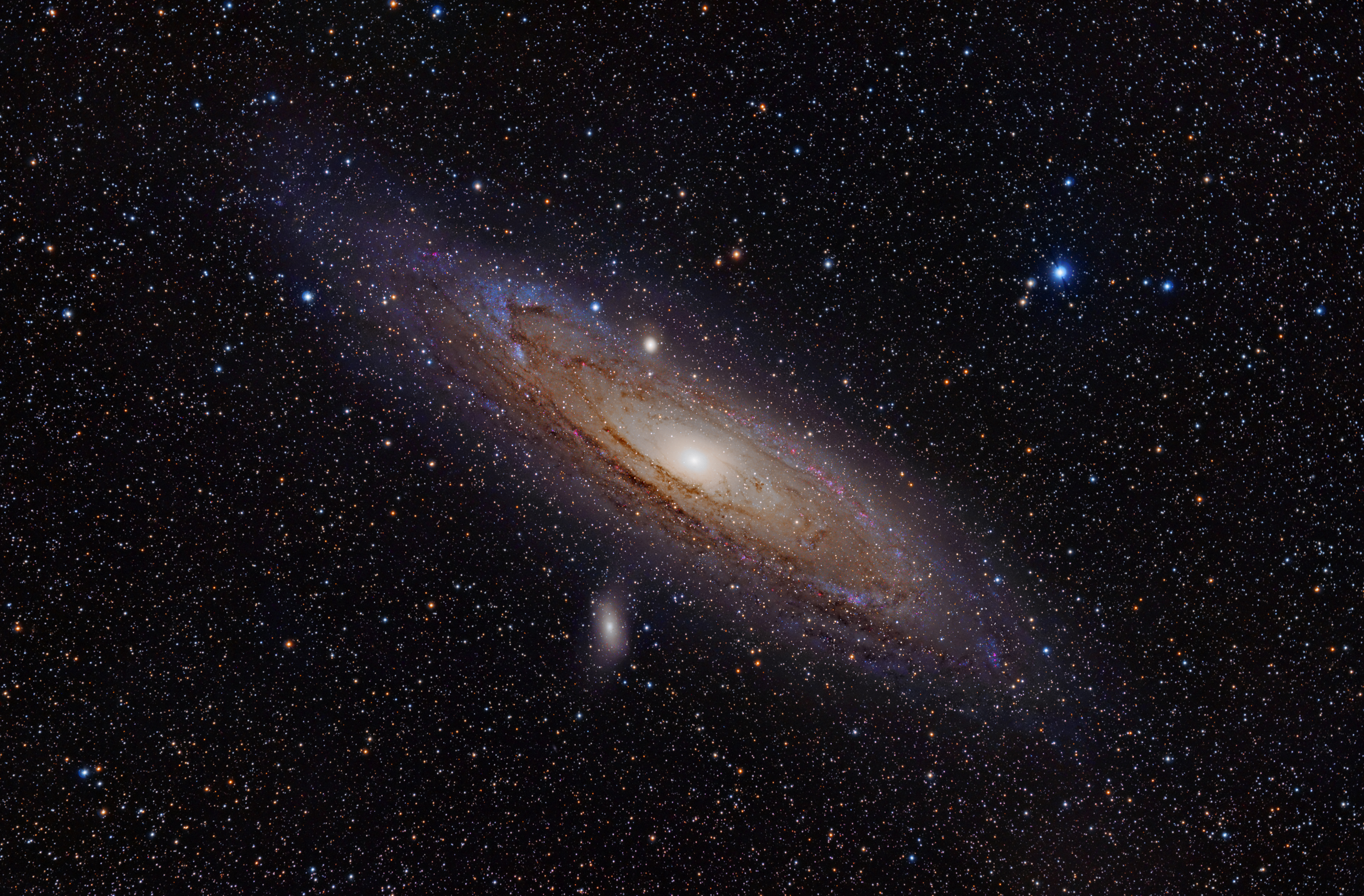
- Autumn (Sep–Nov): Andromeda galaxy (M31) is well-placed. Perseus, Cassiopeia and the Andromeda group are high. M31 is visible with the naked eye from a Bortle-4 or darker site at Polish latitudes.
Digital charts alongside printed ones
Software such as Stellarium (free and open-source) renders a real-time sky view accurate to your GPS location. It is useful for planning sessions — checking rise and set times, seeing which objects clear the horizon, and verifying that a faint target will be high enough to observe before midnight. Using Stellarium on a phone at the telescope, however, requires a red-light filter over the screen to preserve dark adaptation. Even at minimum brightness, a white smartphone screen takes 10–15 minutes to recover from.
The most effective workflow for many observers: plan the session on a computer using Stellarium or SkySafari, print or annotate a chart section for the targets, then use only the printed chart at the telescope. This limits light interference and forces engagement with the sky rather than the screen.
Further reference
International Astronomical Union maintains the official constellation boundaries and naming conventions. The IAU star name catalogue is accessible via their website. For Polish-language resources, PTMA publishes seasonal guides and hosts regional observation events.


